by Sara Dykman
Today was the first day since we left West Glacier, MT nine days ago that we were in our canoes longer than we were towing them by bikes or walking them through the shallow, boulder strewn Cut Bank Creek. Let’s just say the easiest way to travel with canoes is to travel IN canoes.
Now, don’t let the word easiest be confused with the word only, because those 120 miles of biking our canoes and the 25 miles of mostly walking them through Cut Bank Creek were an adventure of a lifetime and these strange modes of transportation were the perfect start to this source to sea trip.
So before I talk about our adventure IN canoes, I’d like to fill you in on our adventure pulling and pushing our canoes. This adventure starts in West Glacier, Mt where a series of friends pulled together and gave us the red carpet treatment. Without them we would still be on the wrong side of the Continental Divide without a plan. Even with the help of our West Glacier alliance coming up with a plan was a four day event that gave way to this:
We packed up all of the stuff we would need (and a lot of stuff we probably don’t need) and put the whole mess on our bikes. THEN we put our two shiny 18’6 Clipper canoes on our Wike bike trailers and towed the whole circus to Lake McDonald a few miles from West Glacier in Glacier National Park.
Lake McDonald is one of my favorite lakes in the world. It’s a ten mile long, glacier carved lake that sits below a castle of mountains. At the lake we transferred all our gear from bikes to canoes and then loaded the bikes onto the canoes. We canoed towards the peaks that to me are like old friends and I can connect the dots of my past between the familiar peaks.

But like I said West Glacier and Lake McDonald are on the Pacific side of the Continental Divide – the long ridge through the Rocky Mountains that separates the waters of the Pacific and Atlantic Oceans. We still needed to pedal over the Continental Divide to get to the right watershed! And that is why at 2am we reloaded our bikes, canoes and all, and began the 3,500 ft climb to the top of Logan’s Pass.

The climb to Logan’s Pass is a ride cyclists dream about. It twists and turns and hands out inspiring mountain views that distract you from the long, upward climb. At 2am the road is ours and we celebrate with loud cheers and M&Ms while we share the darkness with the mountains. By 4am the sun, not yet raised, still managed to spray the valley with enough light for us to make out the panorama of mountains and the distant pass. We take turns pulling the canoe and acting as a pit crew to make sure we get those canoes up and over safely.


At the top we all smile and breathe a sigh of relief. Sure we have nearly 100 miles left to go, but at least we know towing a canoe up and over a mountain is possible. And possible it is. We bike another 40 miles to Cut Bank Campground and wait out some bad weather with the help of generous campground neighbors and home-made pizza delivered to our picnic table by the Cut Bank rangers. And then there is nothing left to do but start. So we hike to the top of Triple Divide Peak, and find the starting line.

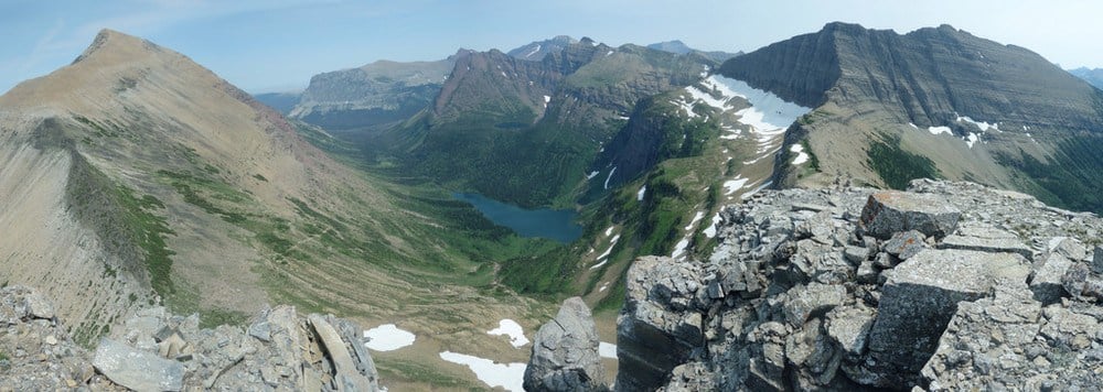
Triple Divide Peak is a small but significant peak in the park, where water can flow to three oceans – the Pacific Ocean, the Arctic Ocean (via the Hudson Bay) or the Atlantic Ocean (via the Gulf of Mexico). It takes less than half a day to climb to the top, 7,397 feet above sea level. And while it is a small mountain I still feel like I am on top of the world.

We eat lunch where three oceans meet. At our feet the Pacific Ocean begins in a slurry of greens, that from a distance line the u-shaped glacier valley like a soft carpet. To our right lays forth the beginnings of the Hudson Bay (that some, including myself for this project, accept as a lead in to the Arctic Ocean). This valley is cut from reds and oranges that bleed into white snows which shelter unnamed lakes that surprise us with their teal blue blush. And then there is the Atlantic Ocean Drainage. Our home for the next five months. Water builds on a green shelf and dives hundreds of feet down to Medicine Grizzly Lake. And at the outlet Atlantic Creek is born. This water is too small for us to do much more than wash our faces and fill our water bottles. And even when it hits the Cut Bank Creek it is still too small.

It is still 75 river miles until we can put in, so until then we pull the canoes by bike. We are all anxious to get these canoes in some water, so after another unnatural early start we pull our canoes by bike (thanks to our Wike trailers) out of the mountains and into the plains along Cut Bank Creek to the town of Cut Bank. No one (including ourselves) can believe we’ve made it, even as we sit at the water’s edge with our canoes packed with 5 days worth of food and enough gear to have a lucrative garage sale, but we HAVE made it.

We get in the canoes and paddle around the bend. Our boats are stable and only sink a few inches with all our gear. When you add two paddlers we sit just four to six inches below the surface. It is quite remarkable, but not enough to let us paddle. One bend in, we are out of our boats and walking. We guide the boats between sneaky boulders and shallow riffles. The days seem to stretch, but our spirits are high we are finally ON the river if not IN our canoes.

And it is a long few days. We walk our boats more than we ride them, in and out we go bruising our legs and our egos, though we are all still in high spirits. We are after all moving forward, moving towards the ocean. The dream is alive.
Cut Bank is a beautiful creek. The steep banks form a protective canyon that is home to hundreds of swallows that paint the sky with chirps and bird poo. Their gourd shaped homes, made by carrying mud in their mouths are a sight to see. Baby chicks beg from the safety of the small opening and the adults pull award winning acrobatics, catching and delivering tasty bugs.

The clean water gets disappointingly less clean as a few murky drainages empty in. We are all disgusted by how quickly we’ve let bad land management taint this water, that still has 3,500 miles to travel and just as many miles to provide drinking water people and other animals. We try to ignore the cows pooping directly into the water and the cow trails eroding the banks. We can’t ignore the now turbid water hiding boulders attacked by algae or the barbed wire strung out across the length of the creek. It is a sorry sight, that with the high bluffs and wilderness feel leaves us all haggard but happy.
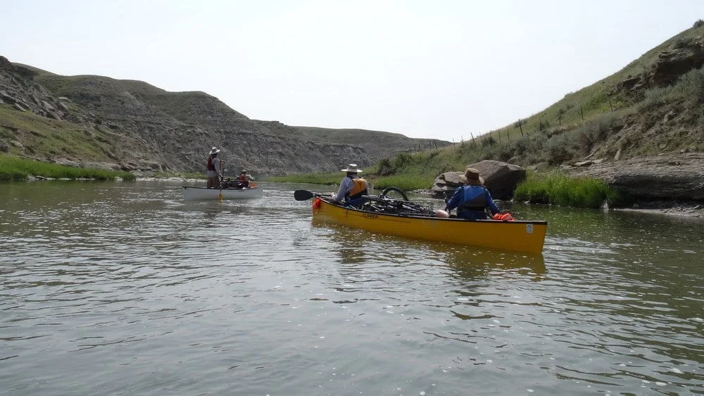
It is a long few days of walking canoes. Aaron and I are in the yellow canoe, Matt and Tommy are in the white canoe, and Nia and Rambo are scouts in the packrafts. Aaron and I spend most of the time jumping from the canoe to walk or frantically paddling. Forwards. Backwards. Go Go Go. More juice. Less juice. Forwards, I mean Backwards. What should we do? Bail Bail Bail!!! etc. It is stressful, but successful. By day seven we are swimming at the confluence of Cut Bank Creek and Two Medicine. Here the Marias River forms, and will be our road for the next 210 miles. Here more water means less (but still some) walking. We paddle on and look forward to the next 3,450 miles to come.
